Contributing to OpenStreetMaps
Originally posted on 5 October 2017, at: https://blog.gramener.com/contributing-to-open-maps/
Improving mapping
With improvements in smartphone technology, in the last decade online mapping drastically improved and is now more accessible. However, majority of the Indians do not speak English which is the primary language of online/offline maps — such as Google maps, Here maps, Bing maps, OpenStreetMap. Independent bloggers have already identified the poor state of our regional maps. Given this, can citizens contribute and improve maps? Technology firms like Google, Microsoft have the resources and infrastructure to make content, albeit slowly, available in different languages. However this data is not open. OpenStreetMap makes all data available for public consumption. The rest of the article is about contributing to OpenStreetMap and steers away from discussing the need of open maps to bridge the digital divide (please see the Additional reading below).
Translating information
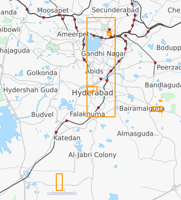
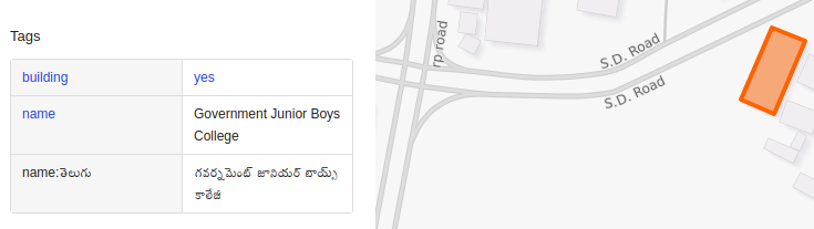
For the next generation of Internet users, the availability of content in their regional languages will be essential for content adoption. Citizen knowledge can be used to translate information of existing places to regional languages. One can easily contribute to translating the content [Steps documented here by Thejesh, a blogger]. The highlighted regions are an overview of my contributions including translations to Telugu, new places, improvements to existing details.
Adding, modifying places
Simultaneously we can add new places, improve existing places/roadways/community locations/highways etc. Community mapping can generate lot of data which in turn can be useful for local economy, civic governance. As places are discovered by online users, it creates scope for more business and higher engagement. Using GPS trace, new places can be added. You have complete control on the data you upload. You can make it public or identifiable or choose to delete it later. Below is a GPS trace I created along a Karnataka highway during one of my travels. I recorded 18 waypoints including hospital, bus stops, fuel stations etc.

Shows the GPS trace between two points on a highway
Mobile apps
1) OSMTracker for Android – Google Play Store You can create GPS trace between any location points and add interest set of points (ATMs, pharmacies, schools, ). For each added point, a timestamp along with the GPS location is recorded. You can upload this back to the OpenStreetMap traces website. 2) OSC – Google Play Store You can take images of view while you are traveling and improve the mapping at a later point. Multiple images covering an area can be recorded and uploaded to OpenStreetCam. You can view the contributions on your profile (example user profile).
Additional reading
1) Need for open maps 2) State of Indian languages on OpenStreetMap 3) Step-by-step tutorial to contribute to OpenStreetMap translations